Features Nレコ - フィールドノートアプリ
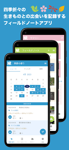
□ What is N-Reco?◆ This is a field note app that allows you to record information on the various creatures you encounter in each season in real time anytime and anywhere.◆ Ideal for recording observations of animal and plant life such as mammals, wild birds, reptiles, amphibians, fish, and insects.◆ Traditionally, field notes are often handwritten or compiled using a PC after outdoor activities, but with the spread of smartphones, we thought it would be convenient to be able to record them in real time in a mobile environment, Developed based on evaluation.□ Main features◆ There is a free plan and a paid plan with limited functionality.◆ Field note creation function● Observation data of living creatures can be recorded in real time.
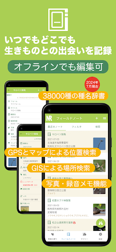
Past observation data can also be entered.● Can be edited offline.
(*1)● Field notes can be narrowed down and extracted using the search function.
It is also possible to replace extracted notes all at once.● Equipped with seven species name dictionaries: mammals, birds, reptiles, amphibians, fish (vertebrates), invertebrates (insects), and plants.
You can also search by order name, family name, genus name, and scientific name.● From the perspective of protecting rare species, it is also possible to confirm Red Data species provided by the Ministry of the Environment by correlating with place names.● In addition to searching from the species name dictionary, you can also select observation history from the life list.
You can enter the species name directly even if it is not registered in the dictionary.
We also have a function that accepts missing species name information.● The map search function using GPS allows you to identify observation locations by place name or on the map.
(*1)(*2)● In addition to standard maps, you can switch between standard maps from the Geospatial Information Authority of Japan, light-colored maps, shaded relief maps, color-coded elevation maps, and the latest national photos.
(*1)(*2)● Offline map available.
(*6)● Observation locations are based on GIS (geographic information system), and can be searched offline by prefecture and city using the place name dictionary.
(*2)● In addition to place names, landmarks can also be recorded, and geographic coordinates (geocodes) can be quoted when searching for maps.
(*1)(*2)● Places and landmarks can also be selected from past visit history.● Two types of memo fields are available.
You can enter information separately, such as public or private.● Photo memos can be registered.
In addition to selecting photos or videos from within your device, you can also take photos using the simple camera function.● Recorded memos can be registered.
In addition to recording with the simple recording function, you can also select audio files on your device.● Field note contents can be copied to the clipboard.● Field notes can be linked together.● Observation data can be plotted and displayed on an observation map.
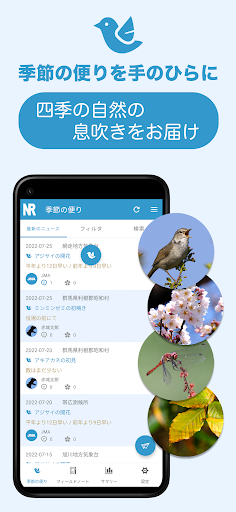
It is also possible to read GPX files from an external source and display track log information.● Field notes can be exported outside the app using the CSV file output function.◆ Seasonal news● Receive phenological observation information sent by the Japan Meteorological Agency as news.● You can send your first observation of the season as an N report.
(*3)● You can receive NRepos sent by NReco users and send likes and responses using the SNS function.
(*3)◆ Summary function● A function to look back on past observation records.● You can follow field notes by month, prefecture, location, and landmark.● You can plot your past visit history on the map and get a birds-eye view of it using maps by prefecture, map by location, and map by landmark.
(*1)● Lifelists are managed by species classification, allowing you to follow field notes based on the species name and check the last recorded date, location, landmark, etc.● You can plot your past observation history on a map and get a birds-eye view of it using the life list observation map.
(*1)● You can pick up photo memos from field notes and display them as a photo album.
You can use Field Notes filter function for searching.□ Trial period◆ You can try it out without any restrictions except for some functions as a trial period for 30 days from the initial installation.*Excluding N report submission.◆ After the trial period ends, it will operate as a free plan.□ Information on paid plans◆ If you purchase a paid plan, the basic functions and all functional restrictions described below will be removed.◆ The price is an annual subscription and the payment method is in-app purchase.◆ User registration is required to use paid plans.□ Paid plan◆ Data items equivalent to note headers such as photo memos can be used for each observation data.◆ The field note editing screen can be customized using the custom form function.◆ With the custom form function, you can add new items that are not standard items as extended items.
Expanded items can also be prepared for each species classification.◆ Search conditions for search filters can be saved individually and reused.◆ Observation traces can be drawn on the map.◆ You can display a list of photos and videos that correspond to the observation date and time using the photo browser.◆ Field notes can be shared externally as PDF files.◆ Field notes can be additionally imported from a CSV file using the CSV file input function.□ About subscription◆ The fee is 2,200 yen/year.◆ Payment for paid plans will be billed via Google Play.◆ Subscriptions are automatically renewed and will be automatically renewed unless canceled at least 24 hours before the expiration date.◆ We do not accept cancellations after payment has been made.
If you are not satisfied with the service during the trial period, please do not proceed with the purchase procedure for the paid plan.□ Additional information◆ Data that exceeds the limit created during the trial period can be used as is after purchasing a paid plan.◆ If you cannot purchase a paid plan after the trial period ends, you will not be able to use data that exceeds the limit.
However, it will be reactivated if you purchase a paid plan at a later date.◆ It is the users responsibility to back up their input data in a timely manner.
Regardless of whether the plan is paid or free, we do not guarantee the security of input data as stated in the terms of use.◆ In the case of the free plan, data imported from an external CSV file that is older than the installation date cannot be manipulated (and displayed) due to functional limitations.
If you want to import and manipulate past field note data, please consider a paid plan.◆ We cannot provide individual support regarding the handling of CSV files.
Please operate only those with knowledge.◆ Although we take great care in development, there is a possibility that some or all of your data may be lost due to unforeseen problems.
Please note that even in such cases, the organizing group (including individuals) cannot be held responsible as stated in the Terms of Use.* Notes1.
Excludes functions that require network connection.2.
Maps and GIS are only available in Japan.3.
Free user registration required.4.
The character code of the CSV file must be UTF-8 and the format must be N record specified.5.
Restoring from a backup set completely replaces existing data.
Also, media files are not subject to backup.
Please be careful when operating.6.
Maps must be downloaded in advance.□ Terms of use◆ https://nature-record.com/term-service.php
Music Features
Enjoy high-quality music streaming and playback features.
Social Features
Connect and share with friends and the community.
Gaming Features
Enjoy immersive gaming experience with various game modes.
See the Nレコ - フィールドノートアプリ in Action
Get the App Today
Available for Android 8.0 and above